Public Information Meeting No. 3 - Draft Secondary Plan
Update
Planning staff would like to thank everyone for a very well-attended Public Information Meeting. Staff are currently considering the comments received and potential modifications based on input. Staff are working towards preparing the final draft documents for formal circulation in the near future.
View the meeting presentation.
April 1, 2026
As the City continues to move forward on finalizing the Northwest Secondary Plan, a draft of the document and mapping schedules are now being made available for review. Additionally, the currently available supporting studies by the consulting team are also available.
City staff have scheduled a third Public Information Open House to allow interested persons an opportunity to listen to staff’s presentation and engage with questions or comments about the Draft Secondary Plan. This is not a statutory meeting under the Planning Act.
The meeting will be held in the Memorial Room at the Gale Centre (5152 Thorold Stone Rd) on April 1, 2026 from 6:00 p.m. to 8:00 p.m. A slide presentation will begin at 6:30 pm.
PLEASE NOTE: Some documents are currently posted, but not all are available. All documents the City intends to have available will be posted under the “Documents” Section on the right side of this page no later than March 18, 2026. Please check back occasionally before March 18 to access any available or newly added documents.
You can access all the available documents on the right side of this page under “Links” and “Documents.”
City staff look forward to your attendance and/or comments.
Comments can be emailed to cmillar@niagarafalls.ca no later than April 8, 2026.
Background Study “Existing Conditions” Reports
To download copies of the available reports, please see the "Documents" section.
Each study reports on existing condition findings. The subwatershed study is the exception to this, given that four full seasons of study are required before an Existing Characterization Report can be completed. The Consultant has prepared an interim report that provides information on what they have undertaken and documented to date. The interim report will be available in the near future and will be posted as soon as it is available.
Transportation Impact – Existing Conditions
This Report documents the existing road networks in the area and provides traffic count information that will be used for benchmarking what the impacts on the area road networks will be under future conditions as part of Phase 2 and Phase 3 work. The report also notes what types of active transportation facilities and transit services exist in or around the area, so efforts to connect to those networks can be considered in future land use planning.
Functional Servicing – Existing Conditions
This Report documents any existing infrastructure within the Plan Area or in the vicinity for benchmarking and modelling. Once land use options have been developed, the modelling will assist in determining the most appropriate and efficient way of providing water and wastewater services to the new community that aligns with City and Regional Master planning.
Land Use Compatibility – Existing Conditions
This Report examines an area around the future community to identify potential sites and uses that could represent potential conflicts to the introduction of more sensitive uses such as residential.
Fiscal Impact – Existing Conditions
This Report examines the existing infrastructure in the Plan Area and provides a snapshot in a per capita approach of costs related to maintenance or capital replacement under current conditions. This will allow for a measure of what the area presently costs the City to maintain and what the future development of the Community may potentially cost to construct and maintain. Once a preferred land use plan is prepared in the final phase, that plan will be used to provide the estimates relating to the capital cost of construction measured against the estimated revenues.
Subwatershed – Existing Characterization (Interim Report)
The nature of a Subwatershed study requires four full seasons of study, and therefore, at this time, the consultant is finalizing an interim report that documents findings to date. This document will continue to be built on as the final Existing Characterization Reporting concludes this summer.
Make sure you are signed up for any Project Updates to be notified of future meetings and document releases.
The Northwest Secondary Plan
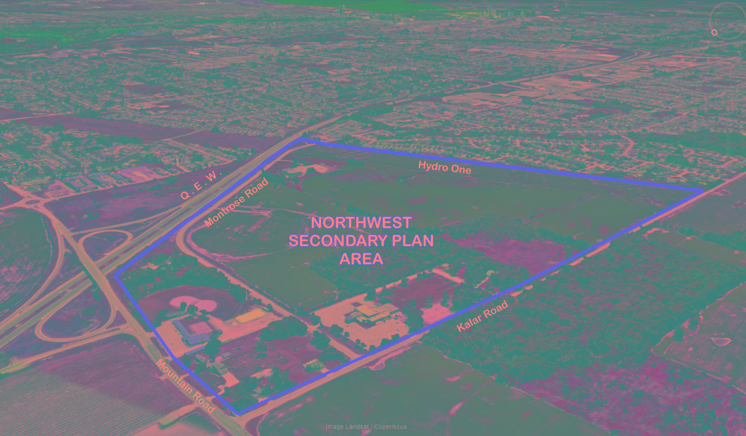
The Northwest Secondary Plan Area is located west of the QEW, south of Mountain Road and east of Kalar Road. The existing residential area south of the hydro corridor represents the southerly limit. The gross total Plan Area is composed of 101 ha. (250 ac.).
In the Spring of 2024, City staff initiated background study work as the first phase of the three-phase initiative. Phase 1 included:
- Consultation with the Niagara Region and NPCA.
- Procurement processes to retain qualifying professional consultants for the various studies required.
- Assembling a facilitated meeting with the Community Focus Group as part of a visioning exercise.
- Meeting or communicating with landowners to arrange site access for consultants undertaking background study work.
- Initiation and completion of Background Reports as noted below.
Project Updates
Planning staff thank those who attended the Northwest Secondary Plan Public Information Meeting, which was held on February 12, 2025, at the Gale Centre.
Digital copies of the Presentation and Display Board Materials can be requested by sending an e-mail to cmillar@niagarafalls.ca
The Northwest Secondary Plan Subwatershed Interim Report is available and provided under the “links” section of this page.
Note: The Northwest Secondary Plan Subwatershed Interim Report will remain “Draft” and subject to changes until it is finalized in the Summer of 2025, following additional study and seasonal field investigations.
Digital copies of the Appendices can be requested by sending an e-mail to cmillar@niagarafalls.ca.
As the City continues to advance the Northwest Secondary Plan, two draft land use options have been prepared to stimulate discussion and generate comments on the potential direction the Plan Area may take in creating a new community in the northwesterly corner of the City’s urban boundary.
A preferred Land Use Plan has not been determined at this time.
The City has scheduled a Public Information Meeting for August 6, 2025, at the MacBain Community Centre (7150 Montrose Road) from 6:00 p.m. to 8:00 p.m. City Planning staff and representatives of the City’s consulting team (GEI, WSP, and Aquafor Beech) will also be in attendance to engage with the public in this drop-in format meeting.
Copies of the Notice and links to the Draft Land Use Options can be viewed and downloaded under the Documents and Links sections of this page.
City staff look forward to your attendance and/or comments. Comments can be emailed to cmillar@niagarafalls.ca
City Planning would like to thank those who attended the 2nd Public Information Meeting for the Northwest Secondary Plan held August 6, 2025, at the MacBain Community Centre, to hear from attendees about the Conceptual Land Use Options 1 and 2.
Attendees engaged with City staff and members of its consultant team working on the various studies required to support this project.
Copies of the Draft Land Use Options remain available on this page at the bottom right under “Documents”.
Copies of the consultants’ cursory feasibility assessment reports, which were available as handouts at the meeting, are also now available under the “Links” section.
If you would like to provide comments to staff to consider as the work towards preparing a preliminary preferred land use plan, please e-mail cmillar@niagarafalls.ca no later than Monday, August 18, 2025.
We thank you for your continued interest in this Secondary Plan project and process.
City Planning staff are wrapping up the Phase 2 (Development Options) portion of the Northwest Secondary Plan’s development, with an administrative report being considered at the September 16, 2025, meeting of Council.
Report PBD-51-2025 discusses the outcome of the two “Options” prepared for additional feedback and consultation. The report also provides a preferred land use concept plan that staff will seek endorsement of Council, before moving into Phase 3 of the secondary plan development process. The Concept remains subject to some additional changes and refinement that will be considered once the more detailed studies and analysis are being completed during Phase 3.
The report is available under the documents section found on the right side of this project webpage or by clicking on this link: PBD-51-2025.
Questions
Questions or Comments
Submit your questions in the text box below, or contact Chris Millar, Senior Project Manager, Secondary Plan, by emailing cmillar@niagarafalls.ca
To ask a question you must create an account or log in.
These are the people that are listening and responding to your questions.
Chris Millar
Senior Project Manager, Secondary Plans
{{question.description}}


